Located in on the Snowy river flooldplain in east Gippsland, Victoria, this was the terminus station that serviced a large area. There were plans for the railway to proceed further east and possibly into New South Wales however sadly this did not occur and like many other stations of its kind, slowly deteroirated and closed down. The railway currently stops at Bairnsdale however the formation to Orbost is preserved in the form of a RailTrail (http://www.railtrails.org.au/).
That is why this layout is so exciting. Lots of research has been undertaken to ensure the layout captures the feel and detail of the area. One of the resources used is Weston Langford's website (http://www.westonlangford.com/).
The site that has been most useful in the project so far would be Google Maps. Screen shot were taken and scaled to resemble 1:500. These shots were then pieced together using signwriting software, printed to scale onto signwriting vinyl and attached to foam. This was used as a base for scaling and sizing of the modules. I will post a photo of this at a later date.
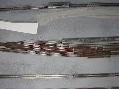
This photo shows the amount of customisation required in the point work to get the track closer to each other like the prototype. The track was also masked up and sprayed to resemble rusty track.

This photo attempts to show the size of the station module. There is a smaller trestle immediately out of the station. There are two more modules, one for the long trestle bridge and the other for the long climb out of the floodplain.


No comments:
Post a Comment